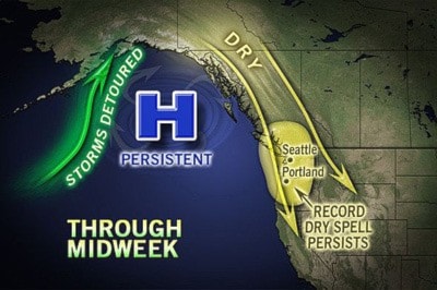
The large, blocking high pressure system that has been fairly persistent over the eastern Pacific since late summer, acting as a block and directing storms and rainfall away from the region is finally break down, allowing the westerlies to return, which will send Pacific storms back into Southern B.C.
The first storm is expected to arrive Friday, followed by at least two or three more storms.
Actually, the storm coming later Sunday into Monday could produce heavy rainfall in the Coastal Mountains as tropical moisture from the central Pacific could be tapped.
The new European Center for Medium range Weather Forecasting (ECMWF) seasonal forecast for the upcoming winter was released yesterday. A few highlights pertaining to the Similkameen indicate;
1. Does not show a strengthening El Nino into this winter, rather near-neutral to barely weak El Nino. This has been a consistent trend lately among models.
2. The model does not show any below-normal temperatures for the winter across 99 per cent of the land mass of North America. The exception is coastal southwestern B.C. and the Aleutians, which is probably more of a reflection of the below-normal sea surface temperatures.
3. Room for cold blasts in western Canada, including the Prairies, though the model is forecasting near-normal temps.
4. Still looking dry for most of B.C., though the model is not as excited about it as the previous runs.