April began with a hot spell, resulting in some melt of the Similkameen snowpack before the weather transitioned into a cool, unsettled pattern for the remainder of the month.
The Similkameen snowpack actually increased through April. Typically snow packs transition from accumulating snow to melting snow around the middle of April, however this transition was delayed this season by one to two weeks.
The Similkameen snow pack is currently at 100 per cent of normal, compared to 79 per cent at last month’s snow pack measurement.
With a slight delay in the onset of the snow melt season, and small increases in the size of the snow pack in some regions, there have been small increases in the seasonal flood risk across the province. Seasonal flood risk is moderately elevated in the North Thompson, South Thompson, Okanagan-Kettle and Liard Rivers. Seasonal flood risk is high in the Upper Fraser basin. Elsewhere in the province, seasonal flood risk is considered to be normal
It is important to note that snow pack is only one element that influences whether flooding occurs during the spring freshet. Of critical importance are how the snow melts and how much, and when, precipitation is received during the snow melt period. While there an increased likelihood of flooding in areas with higher than normal snow packs, flooding is possible in any region given adverse weather conditions (prolonged heat and/or heavy precipitation).
Seasonal flows are expected to be near normal throughout most of the province.
The start of May has brought with it a number of persistent high pressure systems with temperatures that have been well above normal, and in some cases reaching new record levels. This has greatly increased the snowmelt in the Similkameen watershed, especially in the past week.
The current weather forecasts from Environment Canada are indicating hot temperatures through to May 10th or 11th for most of the province, with a slight cooling and chance of wet weather towards the end of the weekend and into early next week (May 12-13). The current NAEFS (North American Ensemble Forecast System) 8-14 day temperature anomaly probabilistic forecast is for a high likelihood of above normal temperatures through the May 15-22 period. The current 30-day temperature anomaly outlook (issued April 30 for the month of May) from Environment Canada indicates an increased likelihood for above normal temperature for southern British Columbia. Longer-range (3-month) seasonal forecasts from Environment Canada are also suggesting a higher likelihood of above normal temperature and below normal precipitation over the May-July period, specifically in the southern half of the province.
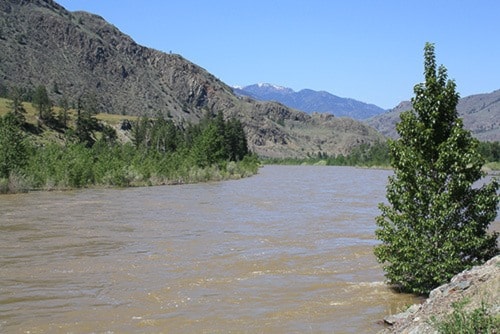
The Similkameen River was discharging at the rate of 416 cubic metres per second as of early Thursday, May 9, up from 177 cms measured on Sunday, May 5.
Thursday’s flow rate (416 cms) is 10 cms short of the two year average return, that is, a flow rate expected on average one year in every two.
On Friday, the Rivers Forecast Centre issues a flow rate of 411 cms, down from Thursday's rate.
A high streamflow advisory was issued for the Similkameen and its major tributaries (Tulameen, Ashnola) on May 8.
River levels in the area were expected to peak Friday or Saturday this week
With temperatures forecasted to ease slightly over the weekend, river levels may ease slightly into Sunday. For more info, contact:
http://bcrfc.env.gov.bc.ca/bulletins/watersupply/current.htm