A six million dollar highway widening project between Twin Lakes Road and the west end of Yellow Lake is the first major improvement to this portion of Highway 3A since its inception as a highway in 1948.
In addition to the major construction at Yellow Lake, road resurfacing is also taking place this spring on Highway 97 between White Lake Road and Gallagher Lake, north of Oliver.
Both of these sections of highway became part of the area’s modern road system in 1948, meant to complement one of the province’s major highway construction undertakings of the day - the Hope Princeton Highway, which was scheduled to open in the late summer or fall of 1949.
In this series of articles, the Review takes a look at some of the history and technology of local highway construction in 1948.
If you’re one of the many Similkameen residents frustrated by highway travel delays due to construction at Yellow Lake, take heart! Travelling the Okanagan and Simikameen valleys has never been easier than it is today - and the delays you are experiencing now will soon be a distant memory when the road widening project at Yellow Lake is completed this summer.
In the meantime, take some solace from this series of articles outlining some of the history and early roadbuilding technology of Highway 3A - and be thankful that it’s 2011, not 1948.
Prior to some major road construction in the late 1940’s that tied the region’s roads into a major southern provincial transportation system, area roads left much to be desired; basically unengineered, they were twisty, winding narrow, rough and slow.
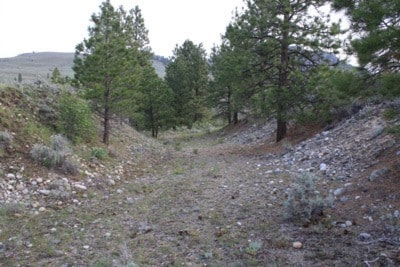
The original trail around Yellow Lake was of limited use because of the high, rocky cliffs lining the shoreline. In 1912, a survey subsequently diverted the road to the hills above the lake, avoiding the north shore almost entirely. Some of this road is still visible towards the west end of the lake, while other parts are now used as driveways for residents living in the hills.
Highway work relief camps were located at Yellow Lake and in the Marron Valley during the early years of the Depression in 1930-31. Work was done to improve the route along the lake, and at Marron Valley, the need to find a new route down to the Okanagan was a priority. The pioneer road was steep and narrow, leading deep into the Marron canyon, and even the limited traffic of the day (particularly buses), were getting stuck on the hills. The road was also so narrow in places that vehicles couldn’t pass each other.
The work parties of the relief camps of the early thirties relocated the road to the south ridge of the canyon, close to today’s alignment. (Traces of the original “S” curves, which were even more sharply curved and steeply dipping than today’s are still visible inside the present set of curves, which were rebuilt to present standards in 1952.) A portion of the old road also exists today as the driveway of Mountain Springs Resort.
(It’s worth noting as well, that the original road to Keremeos once intersected today’s highway 97 at White Lake Road. The road followed White Lake Road for roughly one kilometre, where it then cut northwest, joining 3A in the middle of the “S” curve. Parts of this alignment are still in use as driveways today.)
“There were a few trucks that could make the passage around Yellow Lake prior to building the highway in 1948,” Keremeos resident Betty Borke recalls.
“I remember as a youth, travelling over that stretch in our truck, heading to Keremeos to visit with the Overtons or the Tweddles. It was narrow, particularly around Yellow Lake, certainly not a highway, but more than a trail as well.”
Borke recalls most traffic using the Green Mountain Road, a route that had a history dating back to the pioneer era. The Marron Valley Road saw much greater use as a thoroughfare on the Kaleden side of Yellow Lake back in the late 40’s as well, prior to the improvements to Highway 3A.
Borke related a story mentioned by Joe Detjen, recalled when heavy equipment began construction on the road in 1948.
One of the workers found what was identified as a Spanish shield somewhere near the first long climb out of the Similkameen, north of Stagecoach Road, heading towards the summit at Yellow Lake.
No one knows what became of the object, but its finding lends credence to an old legend that tells of a Spanish column that reportedly passed through the valley in pre settlement days. Legend has it that an altercation with natives in the Similkameen resulted in hostilities that completely decimated the Spanish explorers; the subsequent mass burial of the expedition is reported to lie somewhere in this part of the valley.
Many residents who have lived in the Okanagan- Similkameen for some time have also heard a tale of a bus that ended up in Yellow Lake sometime after the original improvements were made in 1948.
According to research by Randy Manuel, former Curator at the Penticton Museum, records show at least three fatal accidents involving vehicles going into Yellow Lake. Two men were killed on December 19, 1967, when their vehicle left the road at Yellow Lake; a 65 year old man died on December 14, 1959, and on November 24, 1964, a 31 year old died in at Yellow Lake.The incident most likely to have precipitated the story is possibly based on the December ‘67 accident which killed two men. Newspaper accounts of the day told the tragic tale:
(From page one of the Penticton Herald, December 19, 1967)
Bodies recovered from Yellow Lake
Two Lives Taken In Auto Mishap.
Two men, both believed to be from Quebec, whose names have not been released, died early this morning when rescue attempts failed after their car plunged into Yellow Lake.
Divers recoverd the body of one man after searching the depths of the ice-covered lake, 16 miles west of Penticton, at 11:30 this morning.
The body of the other man was recovered inside the automobile shortly after the accident which occurred at about 2:30 a.m. Keremeos police received the call at 3 a.m.
Police said the 1953 model car, travelling east on Highway 3A, ran off a sharp curve and plunged 20 feet down an embankment, flipping over and breaking through the ice-landing on it’s top.
Diver Fred Ryan of the Penticton Fire Department, along with diving partner Ian Folkers, found the second victim on the initial probe of the ice water.
Truck driver Edward Cameron of South Burnaby arrived at the scene shortly after the accident, police said.
The men trapped inside the partially submerged car pleaded with the trucker for help, but he was unable to do anything before the water seeped into the car.
The second victim is believed to have escaped from the car but was unable to surface because of the ice.
They said Mr. Cameron went down to the car but was unable to break the ice to open the door.
Constable Gerald Poegi said he was forced to use an axe to break the ice when he arrived on the scene.
“The doors couldn’t be opened at all”, he said, “and the interior was completely submerged”.
The ice was four or five inches thick .
Police said the temperature in Keremeos at 2 a.m. today was 15 degrees ( F) and estimated it was lower at the scene of the accident.
The road was described as being “in reasonably good condition”. Police said there was no ice on the sanded curve.
The car was pulled from the lake and is in Keremeos.
Names of the two men are: Pierre Beaudain, 19 years and George Drovin, 21.
It was a horrific accident. While the news article didn’t mention the make of the vehicle, Manuel speculates that, given the age of the occupants and the era of the incident, the vehicle might have been a Volkswagon mini bus.
*****
Environmental concerns have helped to boost road construction costs immensely since 1948. Most of the reason for traffic delays in the current six million dollar highway upgrade is due to the fact that the project requires little fill; most of the blasted material must be trucked a distance of more than a kilometre.
It was so much easier to build a road when the first improvements to the road through Yellow Lake were made in 1948. No one worried too much about environmental damage to the lake; most of the rock blasted out of the right of way along the west side of the lake was simply bulldozed into the lake. The present eight foot widening of the highway involves shuttling of 85,000 cubic metres of rock to a dump site roughly two kilometres away from the construction zone, an additional task that has added immensely to the cost and logistics of the project.