Snow measurements for the Okanagan Valley remain above normal, according to the most recent snow survey and water supply bulletin from the provincial River Forecast Centre.
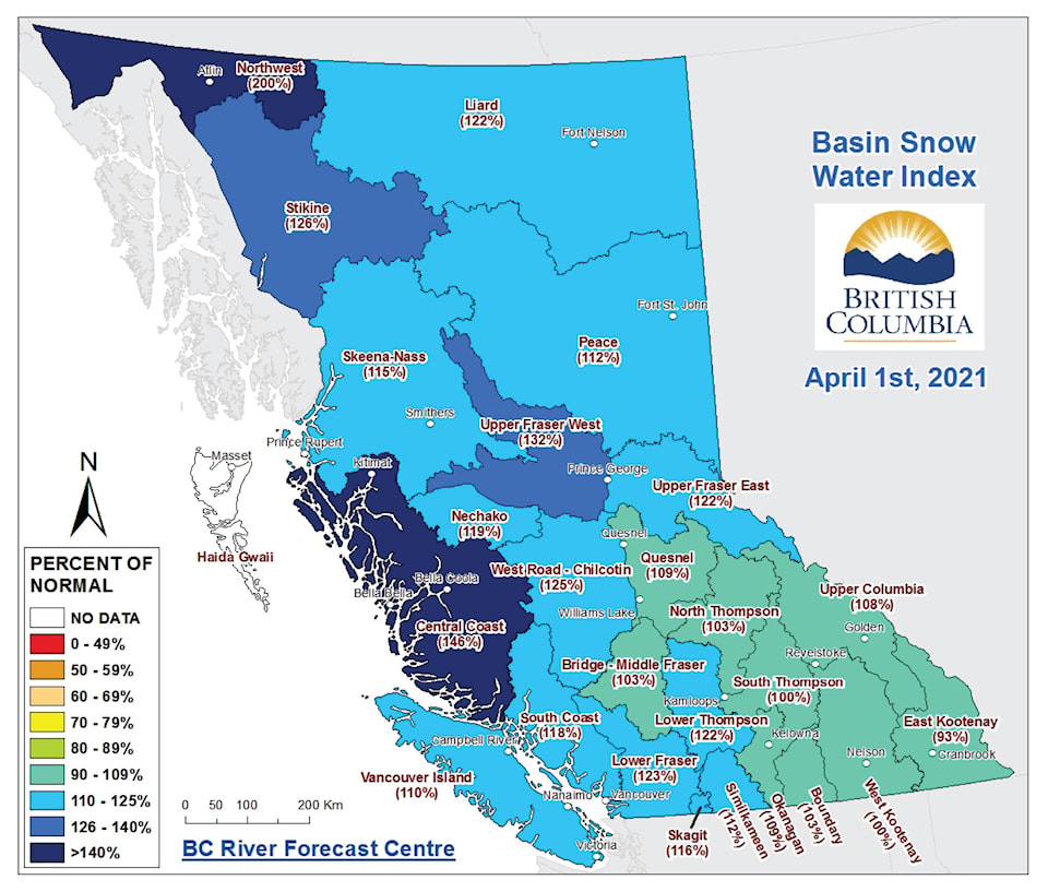
The April 1 figures were released on April 9 and show a low of 93 per cent of normal in the East Kootenay to a high of 200 per cent of normal in the northwest. The East Kootenay is the only region below 100 per cent of normal.
READ ALSO: Summerland’s April 1 snowpack levels near normal
READ ALSO: Summerland Reservoir snow level above normal
In the Okanagan, the snowpack measured 109 per cent of normal. Since the beginning of 2021, snowpack measurements for this area have been well above normal.
The River Forecast Centre said La Niña conditions, which began in the fall, are beginning to ease. According to the U.S.-based Climate Prediction Center, there is an 80 per cent chance of transitioning from La Niña to neutral conditions from May to July, 2021.
La Niña conditions come as a result of oceanic temperature anomalies along the equatorial Pacific Ocean region.
These conditions create cooler temperatures for British Columbia and wetter weather for the south coast and Vancouver Island during the winter and early spring.
This year, since mid-March, temperatures have remained seasonable to slightly below normal throughout the province, resulting in a slight delay in snowmelt. However, warm weather beginning the week of April 12 will affect snowmelt at low and mid-level elevations throughout the province. This could affect smaller creeks and lower elevation areas.
For Okanagan Lake, near-normal runoff forecasts are predicted. A runoff slightly below normal is expected at Kalamalka Lake and Wood Lake.
By early April, nearly 95 per cent of the annual BC snowpack has typically accumulated. Peak provincial snowpack usually occurs in mid-April.
While snowpack is one risk factor for freshet flooding, snowpack alone cannot predict whether flooding will occur, the River Forecast Centre says in its 19-page April report.
Prolonged cool weather, followed by a rapid shift to hot weather, or persistent wet weather or extreme short-term rainfall could also affect flooding conditions.
To report a typo, email:
news@summerlandreview.com.
news@summerlandreview.com
Like us on Facebook and follow us on Twitter.