RDOS Chair Dan Ashton asked Brian Symonds, director of Water Stewardship for B.C., about the implications of this year’s late spring and its effect on current snowpack levels at last week’s regional district board meeting.
“There is a delayed melt this year, with more snow accumulating at higher elevations through April,” Symonds admitted.
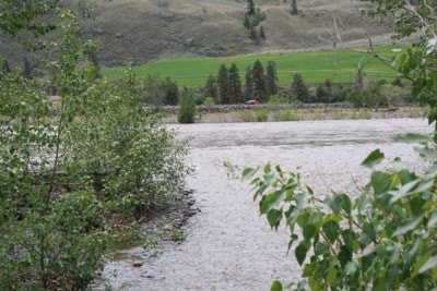
“There is a risk of it coming down too fast.Mid to large streams could pose a threat, and we are anticipating a fairly high volume of water coming into Okanagan Lake.”
Symonds said that the Ministry of Environment was currently releasing water now in an effort to make room for the spring runoff.
“We are trying to manage water levels,” he said.
“The Similkameen valley is more weather dependent than the Okanagan in terms of how runoff accumulates. A spike in flow volumes could pose a danger - there isn’t as much that can be done about that situation. In the Okanagan, the total volume is more the issue than how it comes into the valley.”
The Ministry of Forests, Lands and Natural Resource Operations last week also issued this advisory following the release of April snowpack figures;
The public is advised to take precautionary and safety measures around the region’s lakes and rivers.
Okanagan, Kettle and Similkameen basins:
* Over next few weeks, water levels and flows in streams and rivers throughout the region are forecast to rise significantly in response to melting snow packs and/or rain events.
* The public is advised to prepare for possible flooding of low-lying areas by moving equipment and other assets from these areas to higher ground, where possible.
* During periods of high flow, river banks may be unstable and more prone to sudden collapse. The public is advised to stay well away from the banks of fast-flowing streams and flooded areas or bridges. Young children and pets can be at particular risk during this period.
Okanagan Lake and Okanagan River:
* The Ministry of Forests, Lands and Natural Resource Operations regulates the water flow of Okanagan Lake.
* To create space in Okanagan Lake for the forecasted high inflows from snowmelt, the ministry has increased the release of water in the Okanagan River between Penticton and Osoyoos Lake.
* Flows in Okanagan River are expected to be the highest since 2006.
High flows throughout the system are anticipated to last for several weeks. Okanagan Lake is expected to reach its highest level for the year in late June.
Provincial staff are monitoring water levels, and together with local government officials, they continually assess the risk to the public. In the Similkameen, Keremeos Mayor Walter Despot has been in touch with regional district staff to ensure that they are prepared to handle a flood threat in the Similkameen, should one occur.
Information accompanying the release of last month’s snowpack data also described recent weather patterns defining weather in the region. The report noted that weather patterns in April had been dominated by cooler than normal temperatures throughout the region. Near normal or slightly below normal precipitation was observed through the B.C. interior, and above normal precipitation was observed in the southern portion of the province. Weather patterns are consistent with the La Niña cycle currently being observed.
Normally, the transition from snow accumulation to snow melt occurs at most locations in the province near the middle of April. However this year, the cool April led to an increasing snow pack through most of the province, and a delay in the onset of snow melt. As of May 1 the delay in the onset of melt was about two weeks later than normal for most of the province.
The ongoing snow accumulation and delay in melt has led to increases in snow basin indices in the Okanagan and Similkameen.
Well above normal snow packs (>120 per cent of normal) are present in the Middle Fraser, Lower Fraser, Nicola, Kootenay, Okanagan-Kettle, Similkameen, South Coast and Vancouver Island.
Okanagan-Kettle 145 per cent above normal
Middle Fraser 122 per cent above normal
Similkameen 141 per cent above normal
Increases in snow pack levels and the delay in the onset of melt have led to increased flood risk potential in areas of the province. Based on elevated snow pack levels, increased flood risk is expected in the Okanagan-Kettle, and Similkameen Rivers. Whether or not significant flooding occurs in these systems will depend primarily on the weather during the snowmelt season in May and June.
Snow conditions at the end of the winter snow accumulation period comprise only one part of the peak flow and water supply picture. Spring weather has a large influence on the timing and rate at which the snowpack melts, and will determine whether or not significant flooding occurs. The greatest risk for flooding occurs when there is still significant snow available for melt and weather brings well above normal temperatures and/or heavy rainfall.
Commensurate with existing snow pack levels, slightly above normal to well above normal water supply conditions are forecast for the spring runoff season. This should be particularly beneficial for replenishing groundwater, lake and reservoir levels in regions affected by dry conditions in the 2010 season .
The La Niña cycle that has been present in the equatorial Pacific Ocean throughout the 2010-2011 winter is continuing to weaken, with neutral La Nina conditions expected by June.